Europe's Economic Corridors Deserve Banana Names, Too
Beneath Europe's national borders lie economic corridors that cross them. A playful proposal would name all twelve after bananas, like the Blue Banana.
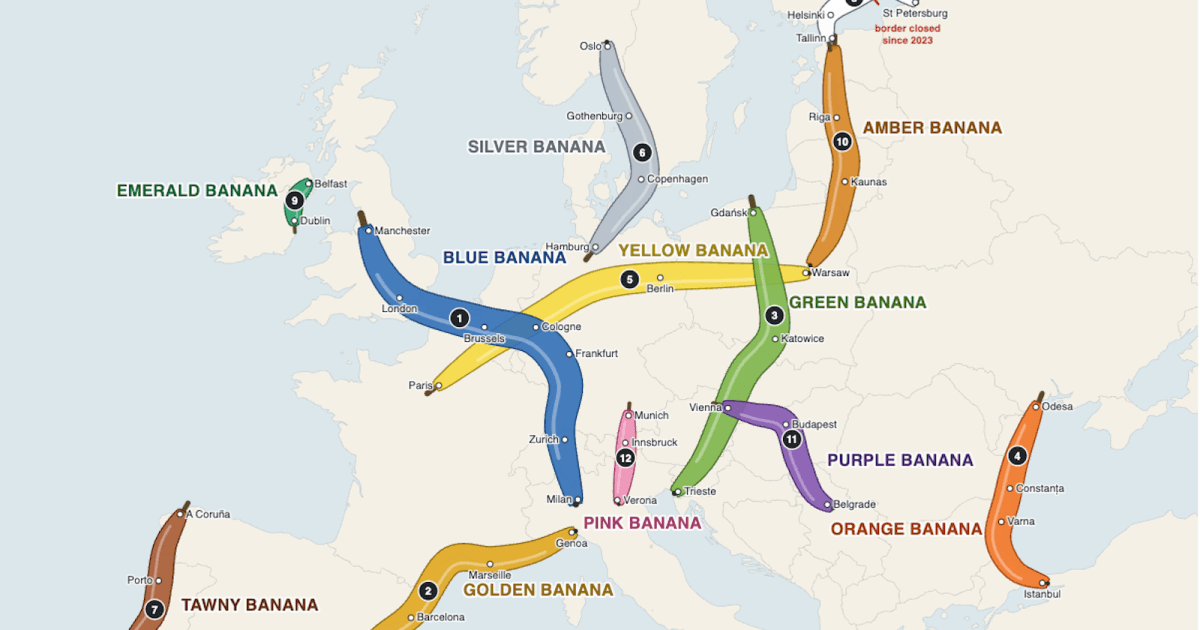
Beneath the political map of Europe’s nation-states lies another map: economic and logistical corridors that cross national borders. The best known is the Blue Banana. Many others are far less visible, largely because they lack an equally memorable name. The modest proposal here is that the European Union, if it is serious about integration, should get silly about names and call all twelve of its major transnational corridors after the bendy fruit.
”Looks like a banana,” said the minister
The Blue Banana is surprisingly recent. French geographer Roger Brunet proposed it in 1989 as an economic zone with shared characteristics, an urban-industrial belt running from Manchester in northern England to Milan in northern Italy. A French minister remarked that the area looked something like a banana, an illustrator for Le Nouvel Observateur colored it blue, and the name stuck.
The nickname did what economic statistics could not: it captured the imagination. It also pointed to a process earlier maps had missed. In an increasingly borderless Europe, proximity and compatibility are creating zones of economic contiguity across several countries.

Roger Brunet’s original map of what he called “the European backbone” (“la dorsale européenne”), later rebranded “the Blue Banana.” Credit: Roger Brunet, La France dans l’espace européen (1989), cited in Cahiers de santé publique.
The Blue Banana has no flag, anthem, or parliament, but it does have a shape, an economic weight, and a catchy name. Names matter because they focus attention and attract investment. That is why a few other zones adopted the banana idea (the Green, Yellow, Orange, and Golden Bananas), while many others did not.
Some corridors labor under unfortunate labels. STRING sounds like something lost in a drawer, and the Atlantic Axis sounds like a pact with a dictator. Coordinated, memorable names would raise the corridors’ visibility and give residents another way to feel they belong, one that transcends national borders. “Going bananas” might also nudge the EU toward economic excellence rather than mere regulatory power.
The map below shows all twelve major transnational corridors as bananas. There is strength in a union: you may crush a single banana, but you can’t bend a whole bunch.
The existing bananas
- Blue Banana: Home to 110 million people, it is Western Europe’s industrial heartland, by some accounts generating up to 40% of the eurozone’s GDP.
- Golden Banana: Also called the Mediterranean Sunbelt or the “North of the South,” it curves from northwestern Italy through France’s Mediterranean coast into northeastern Spain. It combines dense cities, major ports, and heavy tourism.
- Orange Banana: It follows the coast from Odesa in Ukraine through Romania and Bulgaria to Istanbul. It is the Black Sea’s answer to the Golden Banana, with considerable potential at the crossroads of the Black Sea, the Danube, and the Bosphorus.
- Green Banana: An urban-economic arc from Gdańsk on the Baltic to Trieste on the Adriatic, it spans Poland, Czechia, Slovakia, Austria, Hungary, Slovenia, and Croatia. Its potential came into focus only after communism collapsed in 1989.
- Yellow Banana: It runs from Paris across Germany to Warsaw. Its east-west orientation deliberately counterbalances the north-south Blue Banana. It builds on Franco-German cooperation dating to the 1950s, with Poland added to reflect the EU’s eastward expansion.

A more fruitful way of looking at Europe: a Union of Bananas that transcends national borders, revives old economic units and trade routes, and links Europeans from different member states. Credit: Ruland Kolen/Claude
The color of Hanseatic herring
The other seven regions have rather unimaginative names, so comparison to a tropical fruit would be an upgrade.
- Silver Banana: STRING, short for South Western Baltic Sea Trans-Regional Area – Implementing New Geography, stretches from Hamburg via Copenhagen, Malmö, and Gothenburg to Oslo. The silver name nods to the herring on which the Hanseatic League grew rich.
- Tawny Banana: In place of the Atlantic Axis, this corridor would run from A Coruña in Spain to Lisbon via Porto. The name comes from tawny port, the yellowish-brown wine produced in Porto.
- White Banana: Across the Gulf of Finland, the name recalls the white summer nights of the High North. The corridor is incomplete, though. Helsinki and Tallinn are linked by intense trade, traffic, tourism, and investment, but relations with Russia’s St. Petersburg are currently strained.
- Emerald Banana: The corridor between Dublin and Belfast could hardly have another name. Orange, fortunately, was already taken.
- Amber Banana: It follows the Rail Baltica corridor from Tallinn via Riga and Kaunas to Warsaw. The name refers to amber, fossilized tree resin harvested from the Baltic, and the route unites the three Baltic states while linking them to the rest of the EU.
- Purple Banana: The Danube was once a Roman frontier and later the high street of the Habsburgs. In the imperial color that recalls both realms, this corridor links Vienna to Bratislava, Budapest, and Belgrade.
Whatever the color, the point is the same. A good name makes an invisible economic reality easy to see, easy to remember, and easier to rally around.